Prof. Anthony B. Watts
Professor of Marine Geology and Geophysics
Deep-sea sediment processes
Large-scale mass flow on the seafloor
There has been much interest in the past few years in the processes that are responsible in transporting sediments from the continents into the deep sea. Landslides (here used as a general term with no implication of specific failure or transport mechanisms) have now been recognised as a major contributor to downslope sediment transport at passive continental margins and seamounts and oceanic islands. The dimensions of individual landslides are huge : some of them 700 km in length and have estimated volumes in excess of 5000 km3.
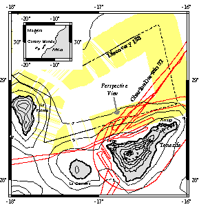
We had the opportunity during 1993 onboard RRS Charles Darwin to acquire SIMRAD EM-12 swath bathymetry data from the north flank of Tenerife, Canary Islands (the figure to the right shows the Darwin tracks). The data from individual 'beams' were smoothed in 25 x 25 m bins and then gridded at 150 x 150 m intervals using a minimum curvature technique. The final step in the data processing was to combine the offshore data with a high-resolution Digital Terrain Model (DTM) from onshore Tenerife.
The figure below shows a perspective image of the combined data set (viewed from the NNW) that was constructed using the Generic Mapping Tools (GMT) software. The surface of the image represents the elevation of Tenerife above and below sealevel and the grey shades reflect the intensity of the horizontal gradients of the elevation in the direction of an artificial sun. The image shows that two distinct types of topography can be recognised on the seafloor north of Tenerife. The first is a relatively rough "ridge and valley" topography which is found on the flanks of the Anaga and Teno massifs.
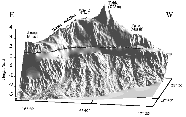
These massifs include the oldest rocks on the island (the Old Basaltic Series) which have been dated as > 3 Ma. The second topographic type is more subdued and comprises of sinuous longitudinal ridges and valleys which have the appearance of flow structures. The subdued topography extends upslope into the Orotava and Icod valleys which Spanish geologists have long considered as of landslide origin. We therefore believe that the subdued zone is part of a huge landslide which has transported a significant part of the north flank of the island into the sea, "scalloping" the coastline in the process.
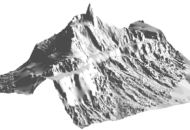
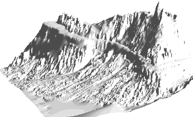
The figures below show two other perspectives of the landslide region : one from NE (top) and the other from the NW (bottom). Both figures show the southern wall of the caldera within which the twin strato cones of Teide-Pico Viejo have built. There is no north wall to the caldera. Either the north wall collapsed during a previous landslide event or the south wall of the caldera is the headwall of a landslide. The top figure shows the western wall of Orotava valley while the bottom shows the east wall. Together, they demonstrate the importance of landsliding in the geological evolution of the island of Tenerife. We plan in the future to study the role of landsliding in the evolution of the other islands in the Canary Islands archipelago.
Collaborators: Doug Masson, Martin Gee, Neil Mitchell
Relevant publications
tony@earth.ox.ac.uk